Research
We use physical modeling, IoT sensing technologies, lifecycle assessment, and various deep learning tools to decipher sustainability challenges in cities.
Full publication list can be found at at my Google Scholar and ORCID pages .
Urban Environmental Sensing
Plume Chasing
Crowdsourced Sensing
Multimodal Exposures
Transport Energy Transition
On-Road Emission Inventory
Hard-to-Abate Modes
Physical Emissions Modeling
Data-Driven Modeling
Wildfire Smoke Attribution
Outdoor-Indoor Continuum
Hyperlocal Exposure Modeling
Emission Compliance Failed for Larger Vehicles
×*Contributed by Dr. Zeyu ZHANG*
Urban air quality suffers disproportionately from a fraction of heavy-duty diesel vehicles (HDDVs). Existing regulations rely on lab tests that fail to capture real-world, high-emitting behaviors. We deployed a mobile plume-chasing platform equipped with fast-response gas analyzers across Hong Kong to test HDDVs in their natural environment.
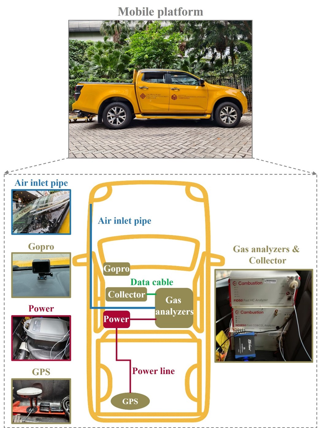
By translating fuel-based measurements into distance- and power-based emission factors, we found that NOX emissions are highly sensitive to road grade and routinely exceed regulatory baselines by over twofold. Shockingly, around 10% of light goods vehicles and 22% of heavy goods vehicles emit NOX at more than double the Euro IV limits. Removing these "super-emitters", who represent just 14% of the fleet, could slash goods-vehicle NOX emissions by 31%.
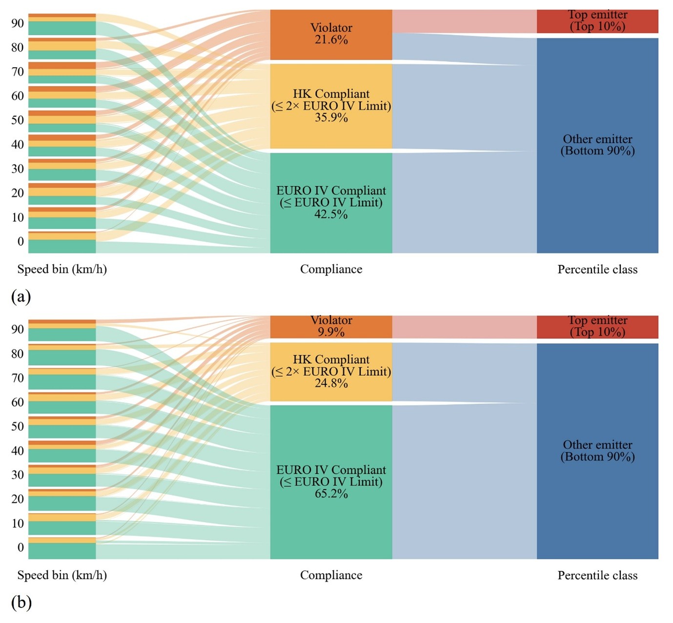
This work highlights mobile plume-chasing as a highly cost-effective, scalable tool for screening high-emitting vehicles and enforcing environmental compliance in dense, mountainous cities.
Democratizing Air Sensing Through Remote Calibration
×*Contributed by Wenyu WANG*
The democratization of air quality monitoring through low-cost sensor (LCS) networks promises unprecedented, block-by-block visibility into urban pollution. Yet, poor data reliability has largely relegated these networks to citizen science rather than rigorous policymaking. Traditional calibration requires physically co-locating sensors with "gold standard" reference stations—an unscalable bottleneck.
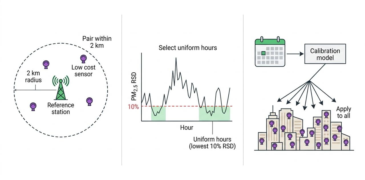
We developed a novel "remote calibration" framework that eliminates the need for physical collocation. By matching over 33 million hourly observations from the largest US LCS network against reference stations during periods of low regional PM2.5 variability, we generated metropolis-specific calibration models. This approach successfully corrected systematic sensor biases across the ten largest US metropolitan areas.
Our calibrated data revealed a stark reality: while LCS networks dramatically reduce spatial monitoring disparities, severe inequities persist, with African American communities remaining the least covered. By proving that crowd-sourced data can be systematically elevated to scientific-grade accuracy, this methodology expedites a paradigm shift toward equitable, hyperlocal air surveillance.
See No Evil?
×*Contributed by Xiaotong ZHANG*
Cities are experienced through a symphony of senses, yet urban planning often prioritizes the visual landscape while treating sound, micro-climate, and air quality as afterthoughts. To quantify this multi-sensory urban experience, we combined drive-by environmental sensing—capturing street view imagery, noise levels, temperature, humidity, and PM2.5—with geotagged social media data serving as a proxy for human sentiment in the Bronx, New York.
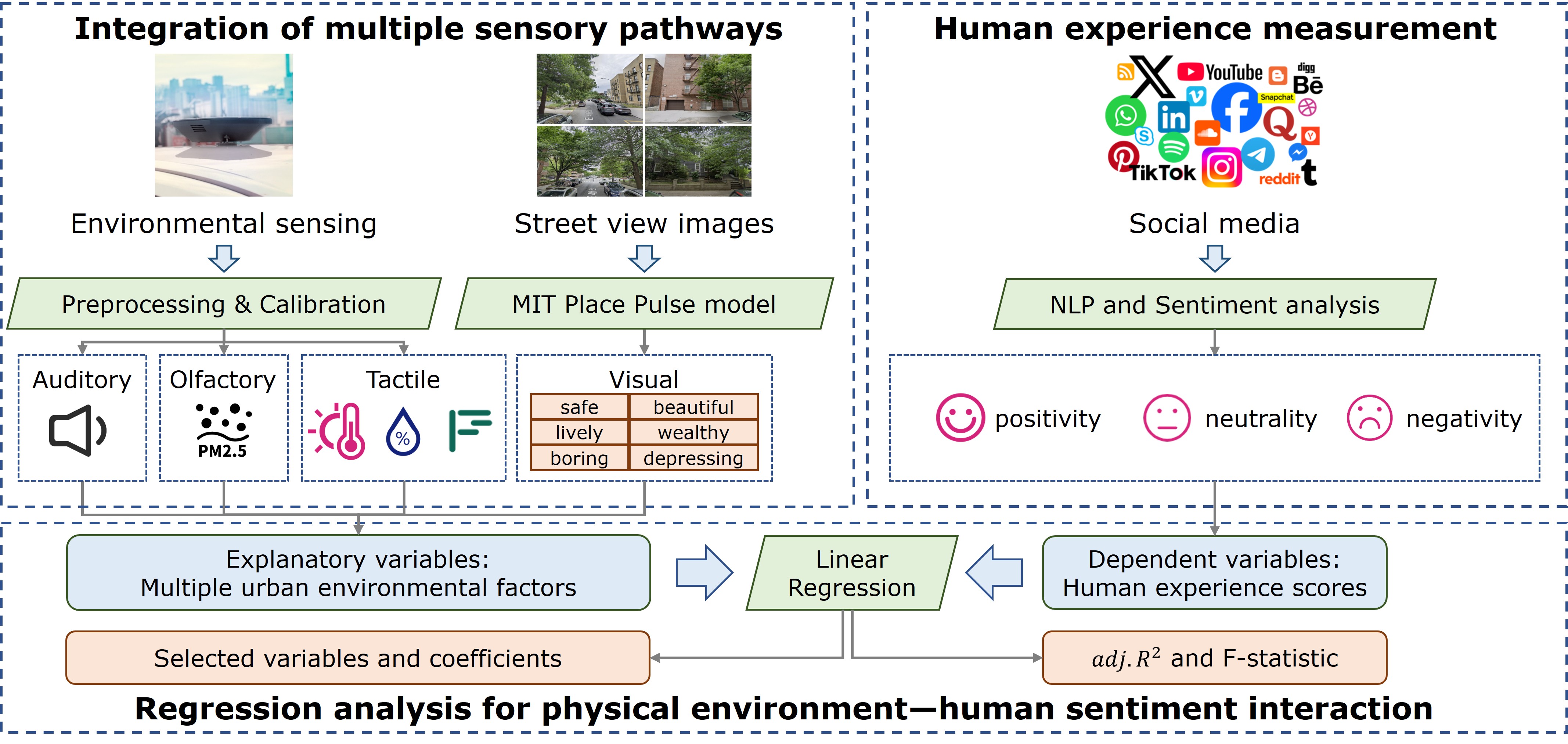
Using machine learning and natural language processing, we mapped how the physical environment interacts with emotional valence. Our results confirm that while visual aesthetics powerfully drive positive sentiment, the invisible environment plays a massive, underappreciated role. High noise levels are strongly linked to negative sentiment and annoyance, outpacing even poor visual environments. Meanwhile, ambient temperature significantly depresses positivity, highlighting the emotional toll of the urban heat island effect.

This underscores a crucial directive for sustainable urban design: creating livable, happy cities requires holistic, multi-sensory interventions—such as deploying green infrastructure that not only beautifies streets, but simultaneously buffers traffic noise and provides thermal relief.
HK Vehicles More Polluted than Expected
×*Contributed by Dr. Zeyu ZHANG*
In our recent study, we demonstrated that neglecting topography fundamentally skews our understanding of urban emissions. By fusing multi-sourced traffic & GIS data and validating the results via real-world plume-chasing measurements, we constructed a dynamic, grade-inclusive emission inventory.
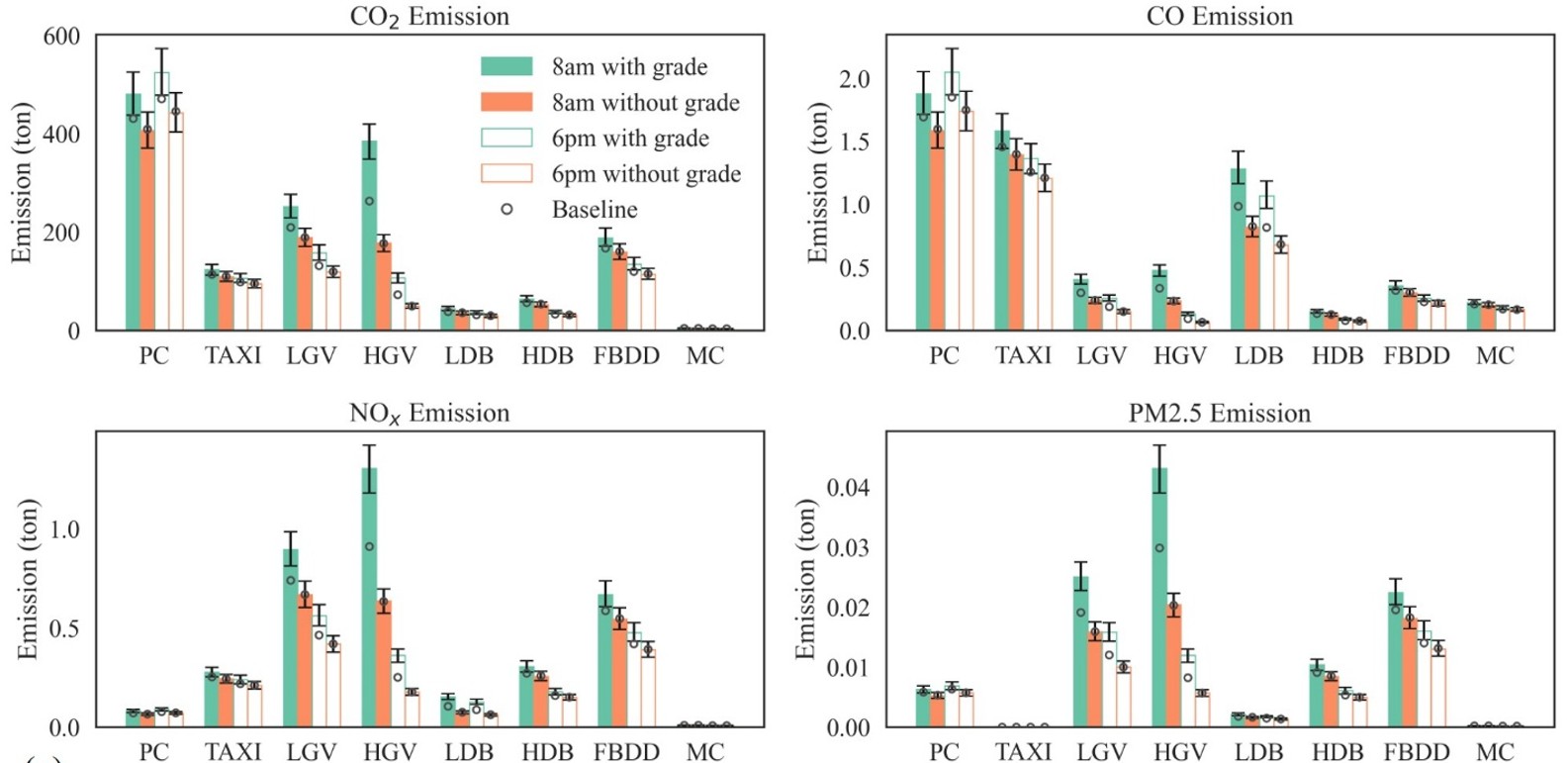
The results reveal a stark reality: downhill emission reductions fail to cancel out the massive fuel penalties of uphill climbs. Factoring in road grade increases Hong Kong’s citywide vehicular carbon and air pollutant estimates by 10% to 30%. More critically, topography dramatically alters the spatial distribution of pollution. Over half of the city's road segments deviate by more than 10% from traditional flat-road estimates. This clusters emission hotspots in topographically complex neighborhoods with heavy-duty traffic, directly impacting local exposure.
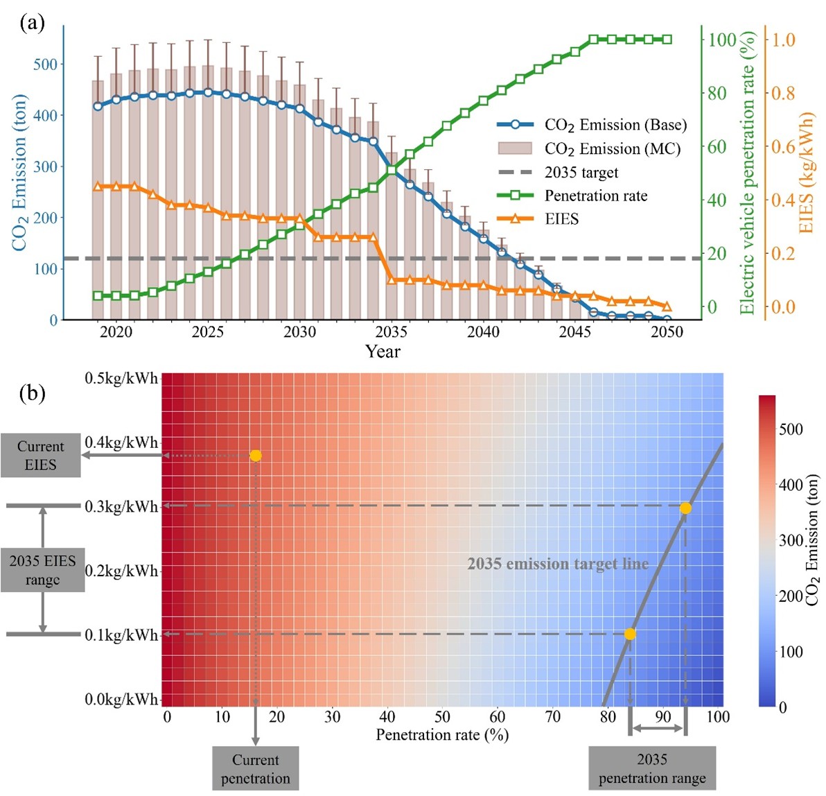
Furthermore, this high-resolution modeling exposes vulnerabilities in current climate policy. When projecting these grade-adjusted emissions, we found that Hong Kong’s ambitious 2035 transportation decarbonization target could face an approximate seven-year delay without a substantially cleaner power grid and accelerated electric vehicle adoption. For densely populated, hilly cities, these findings offer a clear directive: effective low-carbon transitions and pollution control demand that we model our urban systems in all three dimensions.
*Full paper is available at https://doi.org/10.1016/j.trd.2026.105270.*
In Progress to Eliminate Tailpipe Emissions
×For decades, researchers and regulators have relied on rigid regulatory emission models that struggle to reflect the complex realities of modern traffic. Built upon manually tuned parameters and predefined speed bins, these traditional tools often misclassify emissions and fail to accurately capture the dynamic behaviors of transitional technologies, such as Hybrid Electric Vehicles (HEVs), under real-world, aggressive driving conditions.
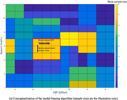
To bridge this gap, we developed novel, data-driven modal emission frameworks powered by extensive on-road Portable Emission Measurement System (PEMS) data. First, we engineered an optimized Greedy algorithm that autonomously defines vehicle operating boundaries. By eliminating subjective, manual binning and integrating internal engine parameters, this methodology improved predictive accuracy for highly variable pollutants like NOx and CO by roughly 30%. We then expanded this high-resolution modeling to decipher the complex, dual-powertrain dynamics of HEVs, utilizing machine learning to predict electric motor engagement in real time before estimating tailpipe output.
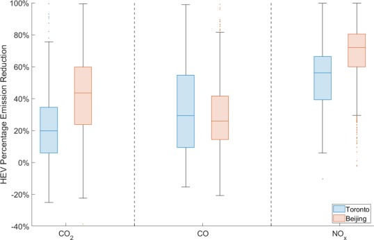
Applying these advanced models across diverse metropolitan traffic profiles—comparing the congested flows of Beijing with the aggressive driving patterns of Toronto—revealed a critical insight. While HEVs are capable of slashing carbon and pollutant emissions by over 50%, aggressive driving severely erodes these benefits. Ultimately, upgrading our physical modeling from static lab approximations to dynamic, real-world algorithms is essential for policymakers to accurately forecast decarbonization trajectories and design targeted traffic management strategies that maximize the potential of low-carbon fleets.
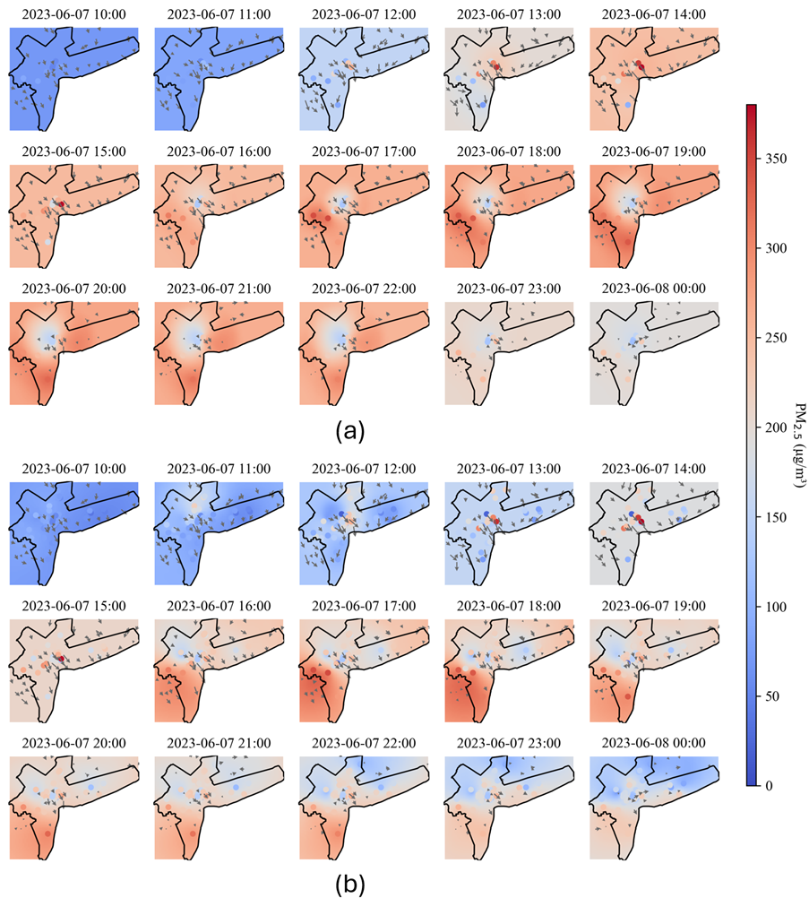
We Breath the Same Air, or Not?
×*Contributed by Dr. An WANG*
Disparities in air pollution exposure are traditionally mapped by linking residential addresses to static pollution data, ignoring the complex realities of human movement. We bridged this gap by fusing the highly granular mobility traces of over 500,000 anonymized users with 100-meter-resolution PM2.5 predictions in the Bronx, New York.
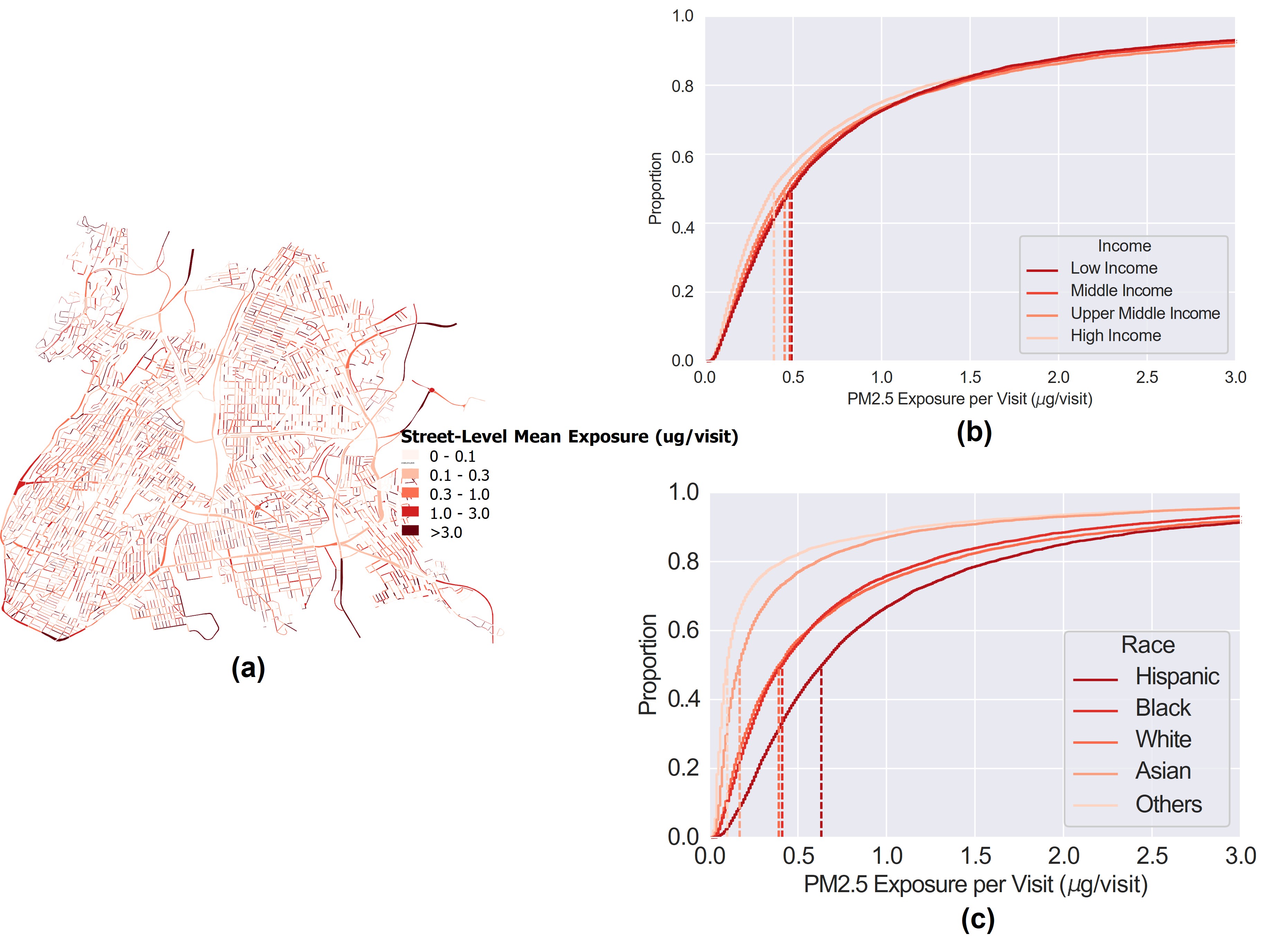
Moving beyond population-weighted averages, our trajectory-based approach tracked individualized exposure across urban micro-environments. The findings reveal that "where" exposure happens matters just as much as "how much". While overall street-level exposure is negatively correlated with income, racial and ethnic divides are far more profound. We found that people from Hispanic-majority communities suffer significantly higher PM2.5 exposure levels than any other group.
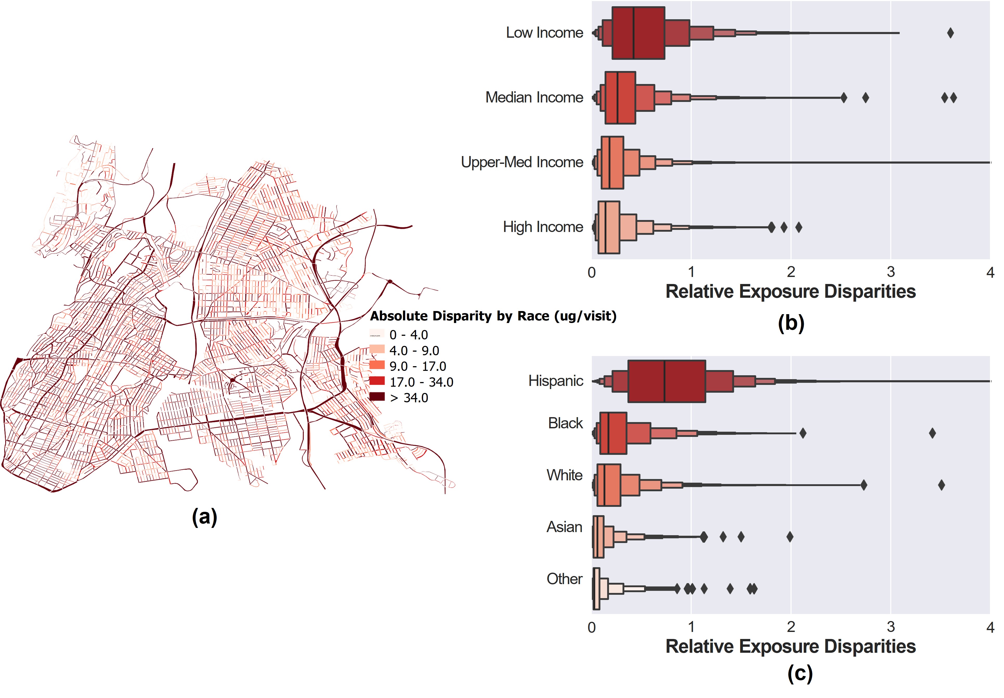
Crucially, our analysis demonstrates that within-group exposure variation contributes to three-quarters of the total disparity, exposing the double burden faced by vulnerable communities. These insights urge planners to move beyond generic, city-wide air quality improvements and adopt targeted, location-specific emission mitigations that actively dismantle systemic environmental injustices.
*Full paper is available at https://doi.org/10.1038/s44284-024-00093-x.*